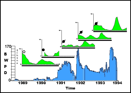
The key well, shown with chronological soil gas hydrocarbon profiles in the timeline, was drilled using geochemical exploration data collected in 1989.
• By 1990 gas concentrations near the producing well decreased. The well quickly depleted the limited reservoir and was shut-in by 1991. Near-surface hydrocarbon gas concentrations remained low.
• In 1991 the well was converted to water injection, and by 1992, hydrocarbon gas concentrations near the well returned to elevated levels. As water injection continued into 1993, hydrocarbon gas concentrations became more elevated.
Near-surface hydrocarbon gas data, monitored during discovery, production, and water injection, demonstrated rapid vertical gas migration from a shallow oil reservoir and the surface. From this data we measured the vertical migration rates in the range 0.6-2.0 m/day (2-7 ft/day).
Details of this study were reported in "Soil-gas Hydrocarbon Pattern Changes During a West Texas Waterflood". Click on the paper title or contact us for a free hardcopy reprint.
Reference: G. K. Rice, J. Q. Belt Jr., and G. E. Berg, 2002, Soil-Gas Hydrocarbon Pattern Changes
During a West Texas Waterflood,
in Surface Exploration Case Histories: Applications of
Geochemistry, Magnetics, and Remote Sensing,
D. Schumacher and L. A. LeSchack,
ed's., AAPG Studies in Geology No. 48 and SEG Geophysical References Series No. 11,
pp. 157–174.